
Snow and Weather Forecasts
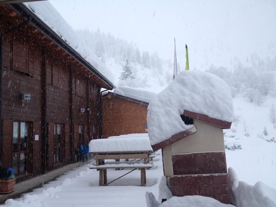

The 'winter quest''anno you wait pi & ugrave; than ever, several ski areas, including La Thuile, Pila Valle d''Aosta, have had to postpone for the second time the' opening, updating the 12/13 December. & nbsp; In Sestriere and in the municipalities of the Milky Way is not the news & egrave; official yet but in the week showed heavy rains up to 1500 meters. In Trentino the heat of these days prevents snow machines to work, but hopefully still in the snow dell''ultimora. From Thursday & Igrave; for & ograve; are coming up positive news on the weather front for the people of the skiers, also confirmed by 3BMeteo in a tweet this morning.
Tuesday 2 December 2014 2 minutes reading time
Between Thursday on Igrave; and Friday & Igrave; the low pressure, reinvigorated contributions from cold, you wear & agrave; eastward. According 3BMeteo arriver & agrave; a little '' air relatively pi & ugrave; cold and temperatures will drop but still remained above the average for the period. Descend & agrave; even the snow line, until about 1000 / 1300m in the Alps of the North West, with flakes also pi & ugrave; down on the Cuneo.
Starting next Saturday, December 6, the snow potr & agrave; whiten even the & rsquo; Apennines, from & rsquo; Emilia Calabria, with accumulations up to 10 cm between Saturday and Monday & Igrave; December 8th. & Nbsp; & nbsp; Saturday snow will start & agrave; to fall albeit weakly on & rsquo; Central Apennines and Tuscan-Emilian above 1800 m, and then lowered to 1300 m at night. Sunday 7 & egrave; expected a truce, with a few flakes can in the night above 1300 m. Regain & agrave; down the snow on the Apennines from Monday & Igrave; evening, with widespread snowfall in Emilia, where the snow level will & agrave; could reach up to 400 m, and in & nbsp; Calabria over 1400 m.
© ALL RIGHTS RESERVED
Social media engagement
More about Snow and Weather Forecasts
Weather and Snow Forecasts
El Niño strengthens: probability of a historic event in winter 2026/2027 rises to 75%
meteo@neveitalia, Friday 11 September, 16:42
Weather and Snow Forecasts
El Niño strengthens further: NOAA forecasts a possible historic event in winter 2026/2027
meteo@neveitalia, Thursday 27 August
Weather and Snow Forecasts
Nuova Zelanda, irruzione di freddo artico: l'Isola del Sud si imbianca
meteo@neveitalia, Tuesday 4 August 2026
Weather and Snow Forecasts
NOAA: El Niño returns—how could it affect the 2026–2027 winter in the Alps?
meteo@neveitalia, Friday 10 July 2026
Weather and Snow Forecasts
Una grande nevicata di fine stagione sulle Alpi: anche oltre mezzo metro di neve fresca nel weekend
meteo@neveitalia, Friday 13 March 2026
Weather and Snow Forecasts
Inverno protagonista sulle Alpi: nevicate diffuse da Ovest a Est, accumuli importanti nel Cuneese
meteo@neveitalia, Tuesday 16 December 2025Ultimi in Meteo e neve

El Niño si rafforza: sale al 75% la probabilità di un evento storico nell’inverno 2026/2027
Il nuovo aggiornamento della NOAA conferma un ulteriore rafforzamento di El Niño. Per il trimestre ottobre-dicembre sale dal 69 al 75% la probabilità che il fenomeno raggiunga un’intensità mai osservata nella serie storica iniziata nel 1950. Uno scenario che dobbiamo monitorare per capire gli scenari possibili per l’inverno 2026/2027.
2