
Snow and Weather Forecastssnow weather
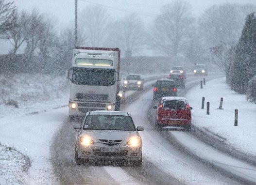

This week will be characterized by the approach from north-west to several times of polar masses of air, which will convey humid currents gradually getting colder on the beautiful country. On Friday, the flakes can also reach altitudes of 1200 meters above sea level, making their appearance in many mountain areas so far untouched by the storming of the bridge on November 1st.
Monday 4 November 2019 2 minutes reading time
Continuous cyclonic vortexes descending from Northern Europe are the cause of this early winter, which follows a period characterized by temperatures higher than normal. And to think that until last week the meteorologists forecast a month of November with temperatures decidedly above the norm!
Today, on the other hand, there are numerous internet sites that deal with weather forecasts that foresee "heavy snowfall in the Alps" (cit. Ilmeteo.it), especially in the central-eastern areas, starting at an altitude of 1500 meters.
Between Thursday 7 and Friday 8, the ilmeteo.it site also predicts that a new unstable front will reach Italy bringing even colder currents (coming from the North Pole) that will further lower the temperatures and consequently also the snow level, towards the 1200 meters with a prevalence of the central-eastern sectors.
Bormio, Livigno, Madonna di Campiglio, Cortina d''Ampezzo will be able to live a winter's advance with the possibility of accumulating up to 10/15 cm of fresh snow. Meanwhile, with the snowfall of last weekend, from November 9th they will be able to give away the dances in Solda and Presena. In Cervnia it is already possible to ski from the end of October.
#NEVE #INVERNO
© ALL RIGHTS RESERVED
Social media engagement
More about Snow and Weather Forecasts
Weather and Snow Forecasts
El Niño strengthens: probability of a historic event in winter 2026/2027 rises to 75%
meteo@neveitalia, Friday 11 September, 16:42
Weather and Snow Forecasts
El Niño strengthens further: NOAA forecasts a possible historic event in winter 2026/2027
meteo@neveitalia, Thursday 27 August
Weather and Snow Forecasts
Nuova Zelanda, irruzione di freddo artico: l'Isola del Sud si imbianca
meteo@neveitalia, Tuesday 4 August 2026
Weather and Snow Forecasts
NOAA: El Niño returns—how could it affect the 2026–2027 winter in the Alps?
meteo@neveitalia, Friday 10 July 2026
Weather and Snow Forecasts
Una grande nevicata di fine stagione sulle Alpi: anche oltre mezzo metro di neve fresca nel weekend
meteo@neveitalia, Friday 13 March 2026
Weather and Snow Forecasts
Inverno protagonista sulle Alpi: nevicate diffuse da Ovest a Est, accumuli importanti nel Cuneese
meteo@neveitalia, Tuesday 16 December 2025Ultimi in Meteo e neve

El Niño si rafforza: sale al 75% la probabilità di un evento storico nell’inverno 2026/2027
Il nuovo aggiornamento della NOAA conferma un ulteriore rafforzamento di El Niño. Per il trimestre ottobre-dicembre sale dal 69 al 75% la probabilità che il fenomeno raggiunga un’intensità mai osservata nella serie storica iniziata nel 1950. Uno scenario che dobbiamo monitorare per capire gli scenari possibili per l’inverno 2026/2027.
695