
Snow and Weather Forecasts
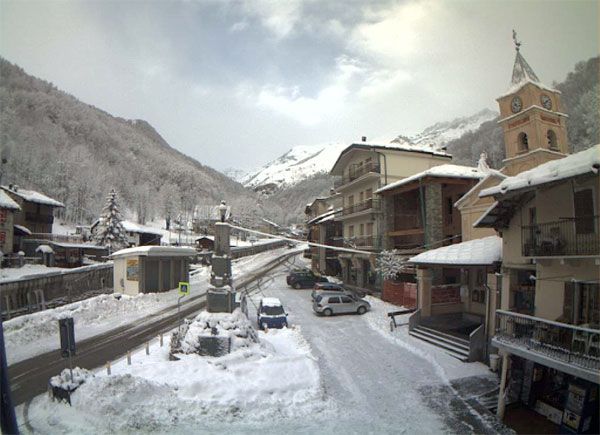

webcam Crissolo

Moderate snow is affecting the whole Alpine region'', whitening on average from the 600-700m height. Since it snowed last night to share in various areas of the Piedmont hills, even on the hills surrounding Turin and Cuneo. During the night the disturbance is propagated to the east by investing all the Triveneto. This morning Aosta, Sondrio, Trento and Bolzano are awakened in the snow.
Tuesday 14 January 2014 2 minutes reading time
The largest accumulations are recorded in the Central Alps, 20-50 cm in Bormio2000 and Livigno in the Brenta Dolomites and over the 1200 to 1400 meters, recording up to 10cm around 1000m on Orobian and western Alps. The accumulations are expected to rise with each passing hour foino to reach more than half a meter of snow. In Trentino-Alto-Adige, in addition to Trento and Bolzano, painted with 3/4 centimeters, the snowfall has been extended to all the ski resorts. They whitewashed Predazzo, Cavalese, Madonna di Campiglio and Cortina is the snowfall is intensifying further in these ore.Nevica over 900-1000m in Tarvisio, while the share in Carnia snow reaches about 600-700m. '' Northern Apennines on the snow falls in excess of 1200-1400m, while the inner compartment Genoese riding Val Scrivia the snow goes up to 350m altitude.
Social media engagement
More details
More about Snow and Weather Forecasts

Weather and Snow Forecasts
El Niño strengthens: probability of a historic event in winter 2026/2027 rises to 75%
meteo@neveitalia, Friday 11 September, 16:42
Weather and Snow Forecasts
El Niño strengthens further: NOAA forecasts a possible historic event in winter 2026/2027
meteo@neveitalia, Thursday 27 August
Weather and Snow Forecasts
Nuova Zelanda, irruzione di freddo artico: l'Isola del Sud si imbianca
meteo@neveitalia, Tuesday 4 August 2026
Weather and Snow Forecasts
NOAA: El Niño returns—how could it affect the 2026–2027 winter in the Alps?
meteo@neveitalia, Friday 10 July 2026
Weather and Snow Forecasts
Una grande nevicata di fine stagione sulle Alpi: anche oltre mezzo metro di neve fresca nel weekend
meteo@neveitalia, Friday 13 March 2026
Weather and Snow Forecasts
Inverno protagonista sulle Alpi: nevicate diffuse da Ovest a Est, accumuli importanti nel Cuneese
meteo@neveitalia, Tuesday 16 December 2025Più letti in Meteo e neve

NOAA: torna El Niño, come potrebbe influenzare l'inverno 2026-2027 sulle Alpi?
La NOAA (National Oceanic and Atmospheric Administration) ha pubblicato il 9 luglio il nuovo aggiornamento sul fenomeno climatico ENSO (El Niño-Southern Oscillation), confermando che El Niño è ormai in pieno sviluppo e che continuerà a rafforzarsi nei prossimi mesi. Secondo i climatologi statunitensi, il fenomeno dovrebbe raggiungere il proprio massimo proprio durante l'inverno boreale 2026-2027, con una probabilità del 97% di persistere fino alla primavera 2027 e con possibilità sempre più elevate di raggiungere un'intensità tra le più elevate osservate dal 1950.
2